
The BLM is accepting public comment for 6 amendments to the Moab, Price, and Vernal Resource Management Plan. These amendments are part of the process to implement the Dingell Act which created 600,000 acres of wilderness in Emery County, cherry-stemmed hundreds of miles of roads, created national monuments, and will set the stage for recreation access in these areas for decades. SUWA is already mounting their fight. Even though this legislation was written to define public land management in Emery County, Grand County leaders are using these planning process to further their agenda of trying to close as many roads as possible in Grand County. We need everyone to submit comments or many areas that people love to ride in Southern Utah will be closed down. We know that trying to keep up with these processes is exhausting, and we believe the process is designed to wear you down to where you give up. We’re tracking all these issues, so you can add your voice to ours and stand strong against these efforts to close our public lands that are coming from all directions.
This is the letter Grand County is sending to the BLM:
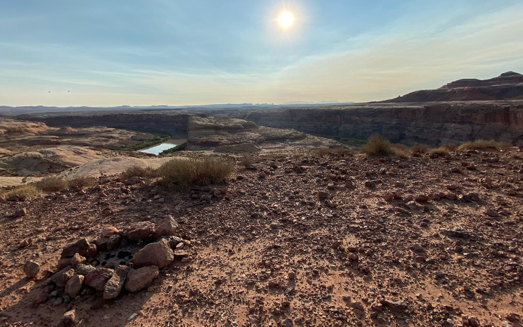
You will see they are proposing the closure of several significant motorized routes, “The designation of the Labyrinth Canyon Wilderness in Emery County is incomplete without similar management of the Grand County side of the river. One cannot have a ‘wilderness experience’ while camping directly across from a regularly utilized motor vehicle route. The way that canyon walls ricochet sound coupled with the increased usage of unusually loud vehicles, such as side-by-sides and motorcycles, essentially ruins that experience for thousands of recreationists every year. Therefore, the Grand County Commission supports analyzing the following areas for closure or alternate management scenarios: the Hey Joe motorized route along the river from Spring Canyon, downstream of Spring Canyon, along the river towards Hell Roaring Canyon, Hell Roaring Canyon, 10 Mile Canyon, and the Dead Cow Motorcycle route. Closing these routes to motorized use would represent a small loss for users considering the extensive network of motorized trails found virtually everywhere in Grand County, many of which have incredible vistas of the Green and Colorado Rivers or provide direct access to those same rivers. In contrast, there is no comparable opportunity for a wilderness quality, family friendly, accessible flat-water river trip.”
We agree with the analysis from Colorado Off-road Trail Defenders regarding these closures:
In this the Commission is asking the BLM to blatantly violate federal law by closing motorized routes because of sound impacts to adjacent Wilderness from outside the Wilderness area. The Dingell Act specifically prohibited the BLM from creating buffer zones or from considering sight or sound impacts on the Wilderness from activities outside the Wilderness as reasons to prohibit those activities. Each of the Wilderness designations in the Dingell Act included the following language:
Adjacent Management.–
(1) In general.–Congress does not intend for the designation of the wilderness areas to create protective perimeters or buffer zones around the wilderness areas.
(2) Nonwilderness activities.–The fact that nonwilderness activities or uses can be seen or heard from areas within a wilderness area shall not preclude the conduct of those activities or uses outside the boundary of the wilderness area.
In terms of motorized travel management, this Congressional language specifically prohibits the BLM from closing motorized routes based on sight or sound impacts to nearby Wilderness areas across the Green River from the motorized routes on the east bank. The Commission is therefore asking the BLM to violate federal law by considering factors Congress has forbidden it from considering in the RMP amendment process.
It should also be recognized that they are trying to limit access for aircraft and drones, “Over the years, there has been a steady increase in the use of small aircraft piloted below the rim of Labyrinth Canyon. Of particular nuisance to those enjoying quiet, scenic backcountry river trips are paragliders, which create a very high pitch drone that carries great distances through the canyon. We would like the BLM to consider limiting the overall use of the Mineral Bottom airstrip as well as other backcountry airstrips in the vicinity, as well as considering limits to particularly loud and low-flying aircraft.”
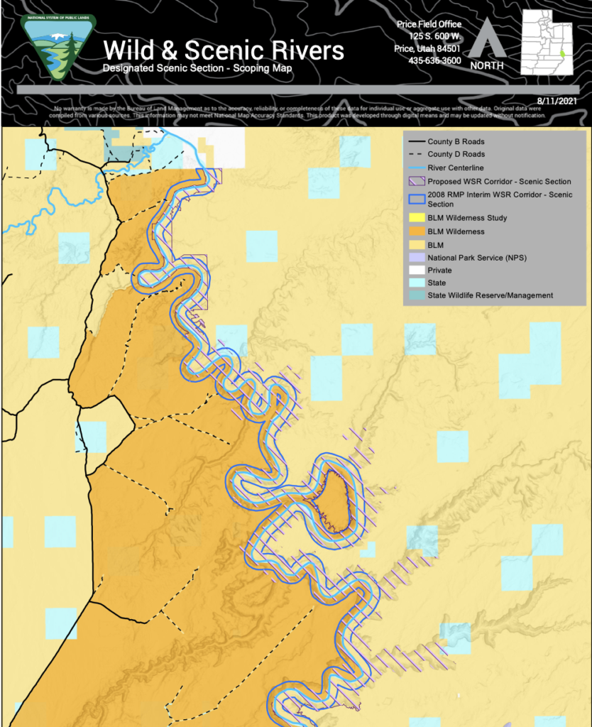
We have an action alert for the first plan amendment and we will continue to add action alerts so you can be involved in every step of the way. These comments are all due Jan. 7th. Our first focus is the Green River Wild, Scenic, and Recreational River Segments amendmnet. Through this amendment, BLM is using the wild, scenic and recreational river designations in a way that could potentially create wilderness buffer zones. Motorized watercraft also access the river in these areas, and these designations could impact motorized use on the river in addition to justifying motorized routes near the river.
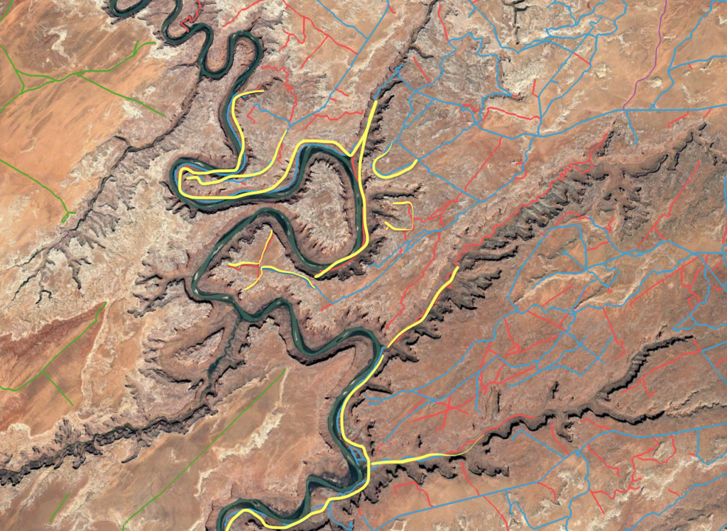
These two maps show our primary concerns. The purple diagonal lines run outside of the blue WSR corridor on the map on the left, and if those areas are designated as scenic segments, it will give BLM justification to close all of the routes highlighted in yellow on the right. These are routes we will be fighting aggressively to keep open in the Labyrinth Rims/Gemini Bridges Travel Management Plan, and we need to make sure our efforts aren’t undermined by Wild and Scenic River Designations:


no net loss of any recreation for anyone should be the objective.
I have been enjoying Moab for the last 20 years.
While there may be some that spoil it for the rest of us, most of us are considerate users.
A lot of us are older and we have invested heavily into vehicles that will allow us to enjoy the landscape. I hate to see trails get closed because of some selfish users that only want it for themselves.
please follow the laws and do not restrict our access to these lands for recreational purposes.
Road access needs to be maintained to trailheads and other jumping off spots for hiking/biking and for dispersed camping.
My core group of friends and I have been visiting Moab twice per year for about 20 years. Our passion is dual sport motorcycling. We stay the trail and are respectful of other users. We typically stay in local Airbnb’s or motels and utilize the abundant great restaurants Moab has to offer. I object to the closure of legacy trails for the benefit of wilderness users. We need more places for motorized recreation, not less. Thank for permitting me to express my opinions and concerns!
As a disabled vet I have fallen in love with Moab. I physically can not hike or bike to some of the absolutely stunning places your OVR trails have taken me. Please keep your OVR trails open as they bring so much to everyone.
Seriously, the blatant greed of grand county to block everyone’s access except their own is beyond political, it is immoral and discussing.
Grand county does not own the land we the people of Utah and the United States do.
This has to stop and grand county should be sent a big message of disapproval of their greed and corruption.
Family and I regularly ride off road motorcycles around this area and stay in or around Moab. We also spend a fair amount of money there and enjoy family riding on the well established trail systems there. Please keep them open to all motorized use.
You will lose tourist dollars if this happens. Moab is unique in the 4wd world and holds a special place. You will lose my $$ for sure.
Although I have yet to experience this area, it is on my retirement “bucket list”. I expect that we would explore via jeep, foot, water and whatever else mode we may find appealing. “Separated” recreational use will inevitably lead to favoritism of one or the other and reducing the current diverse user community. As we lose more riding areas, this puts increasing pressure on those that remain, which then in turn creates calls to close these areas as well.
Please maintain the current recreational system that allows for a myriad of uses while protecting the natural environment.
My family has been going to Moab for 50 years or better. We visit Moab several times a year. We go to town spend our money on eating and shopping. Twice a year my family has a spring and fall family trip every year. We meet with friends that are like family from all surrounding states. We love the beauty that Moab and the surrounding area has to offer. It will be a shame and quite disappointing if we to not be able to enjoy the beauty. I hope this all stays open for the public to use. More importantly to the person reading this, Please respect the land and clean up after yourself. The dirtier we are and more disrespect of the land is like throwing gasoline on the fire.
I’ve had the opportunity to use my side by side multiple times over the past few years to access camping and hiking in the area in and around Tenmile. The Grand County claim that popularity of side by sides are degrading to the area seems false to me. Unlike trails that are close to Moab this area sees very little use. You are likely to never see another user while in the canyon.
I would like to see an honest assessment of how many Grand County “ Officials” have actually been there? Or does the area simply look like a good place to close because they hope no one is paying attention.
I would like to see the area remain in its current state. If the trails were closed to motorized vehicles I don’t see how I t would benefit hikers in anyway as Grand County claims. Very few people would be able to complete the hike in Tenmile to the river. It is at least 15 miles from Dripping Springs to the Green River.
Yes, there are a few loud and obnoxious side by side users. What people don’t realize is that Moab/Grand County does not enforce current sound restrictions. They are more than happy to welcome these loud uneducated users. To county officials see these noise creators as a prime tool to drive a wedge into the community by saying “you hear that loud UTV”. There are thousands of off roaders in Moab, very few are loud. If these loud bad apples were dealt with as the law says they would not be in Grand County at all. One should always be concerned when a government does not enforce its own laws, what are their true motives?
Grand County represents their would agenda, they do not represent the views of all of their constituents, especially not me.
Public lands should remain open for the public to use and recreate as we see fit. It shouldn’t be limited to just one type of user group. We all pay taxes to support these lands and we all should be able to use them equally. Please keep our public lands open for all users, especially for those unable to enjoy them without motorized access.
Limiting access to public lands by the public should not even be considered. Motorized travel of public lands is a 12 billion dollar a year industry that creates thousands of jobs, restricting motorized recreation on public lands would hurt the Utah tourist industry and kill jobs.
This area is very viable to all aspects of public use and should remain so.
I have been a user of public lands my entire life. My main hobby for the last 60 years has been traveling, and exploring and camping on public lands. Public land should be public, this means open to all users at all times. Your mission should be mainting and improving access to on public lands.
My wife is severely handicapped and with my help she can enjoy these trails on our Jeep or ATV. By closing or locking these up these trails forever you are denying her access and freedom to enjoy them. Us baby boomers can no longer carry 50 pound backpacks and off roading is our only way left into the backcountry. These people who want to take this away from us have no conscious of what their doing to us. Apparently they figure they will never get old.
Keep our lands open for all to recreate on.
Motorized vehicles have responsibly recreated here for generations.
There is so much land in Central and Southern Utah already designated as wilderness, National Parks, or other user limiting restrictions that we have to ask, when is it enough? my wife and I, have been riding and biking and camping in that area for close to 40 years and we have seen much of the area placed into supposed Wilderness Study Areas.
There are many of us who would not be able to enjoy those areas without the use of ATV’s or bikes. There are many areas with only foot or horse access that should satisfy those who wish to hike or camp somewhere without seeing or hearing a motorized vehicle.
Please do not close any more public area to ATV or Bike use, or dispersed camping. Many of us prefer to camp in the “wild” rather than side by side with other campers.
Thank you.
Please do not lock us out of these trails along the Green River. I enjoy Hey Joe Canyon, Hell Roaring, and 10 Mile Canyon one or two times each year. I have lived in Moab most of my nearly 72 years. I know individuals who have been directly or have family members who work the mines at Hey Joe. I and some of my cousins lived in a house at the base of the cliffs when Thornburgs operated the mines in the early 60s. I and many of my friends (mostly near my age) are not healthy enough to safely enjoy these areas by foot or bicycle. I try not not even go out alone using motorized travel for fear of breaking down.