The Bureau of Land Management in Clark County, Nevada has released the draft plan and environmental impact statement for the Rough Hat Solar Project. Public comments are being accepted on the proposal through April 11, 2024.
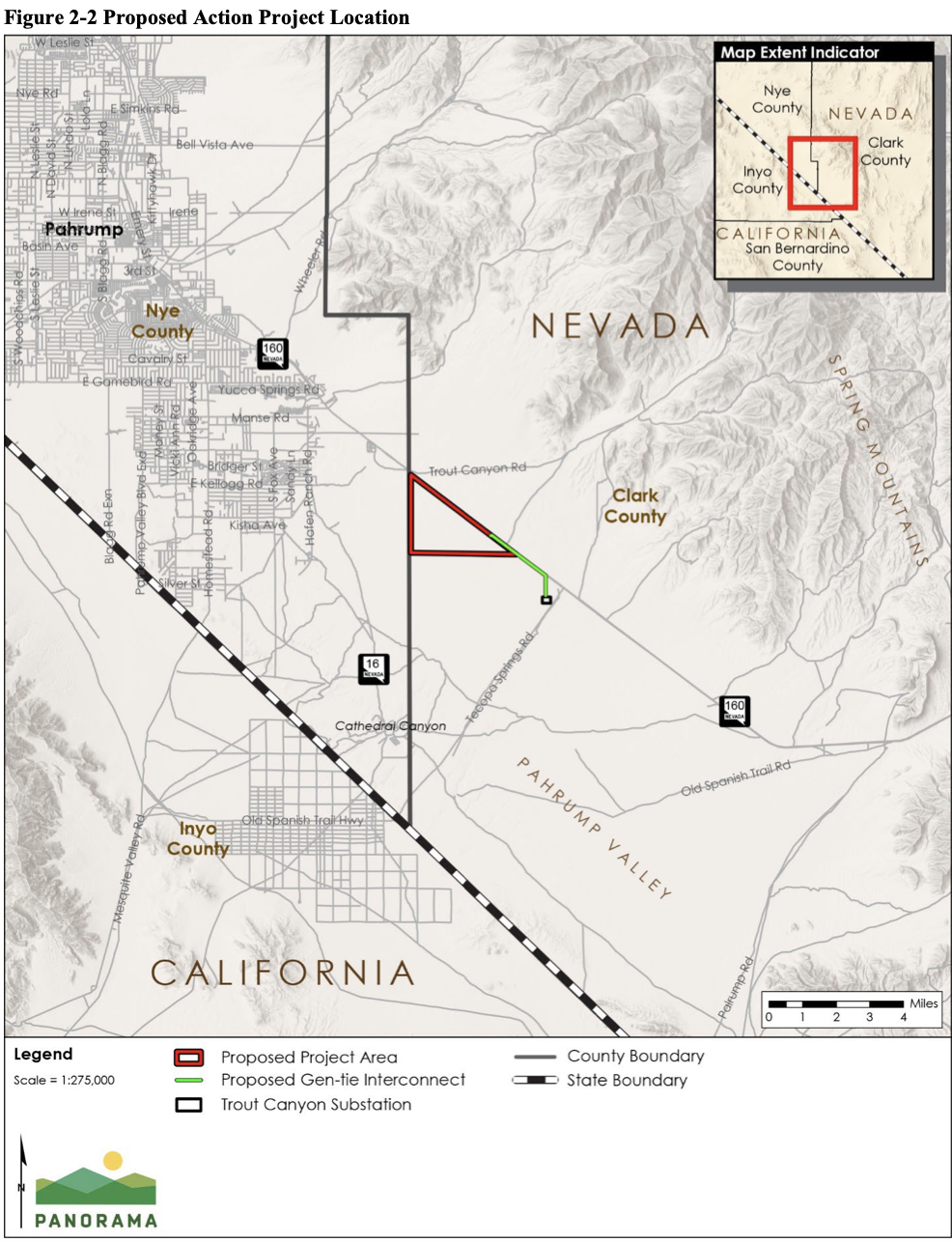
This is one of many proposals we are seeing throughout the western United States. This specific project is located in the Pahrump Valley, next to the established Copper Rays solar farm. There is a massive push to develop solar farms on public lands. In 2012 the BLM created the Western Solar Plan to identify Solar Energy Zones (SEZ) that were best suited for solar farms in which these types of projects would be prioritized. The BLM is currently in another public comment phase to update the Western Solar Plan to include more areas acceptable for solar farms and available for a streamlined permitting process. The Rough Hat Solar Project however is not within an SEZ. BLM should only be allowing solar farms within SEZ’s while there is currently available land for those types of projects. Solar projects, if approved should not be developed in areas that are currently used for other uses. Solar use should not be prioritized over all other uses.
Recreation does occur within the 2,433 acres of the proposal and around the project area. The project is expected to close these acres of land for approximately 30 years. It is located south of Big Dune Recreation Area and in fact, the proposal is also located within the Southern Nevada Extensive Recreation Management Area (ERMA). This area is designated for recreation, not for solar farms according to the 1998 Las Vegas Resource Management Plan. The analysis areas also includes Stump Springs Area of Critical Environmental Concern (ACEC) and Spring Mountains National Recreation Area.
Roads throughout the project area are SR 160, Trout Canyon Road, Old Route 16 other existing trails which include dry wash which OHV’s are allowed to use as trails. The current route designation is limited to existing trails in which there is approximately 2.5 miles, and dry washes which means, the amount of trails within the project area are limitless. The entirety of the project is within 15 miles of 583 miles of routes. The Environmental Impact Statement confirms that dispersed camping also happens within the project area although the BLM has not documented this use. There is also one active ad two proposed special recreation permits for this area. It is assumed, if the project is approved these permits would be cancelled or denied moving forward, greatly affecting the permittees. BLM also identified the following forms of recreation use in the area: equestrian, hiking, camping, hunting, and target shooting.
The proposal does not conform with the current visual resource management plan. In order to move forward with the proposal the BLM would need to amend the 1998 plan. Currently the area is designated as a Visual Resource Management (VRM) Class III and in order to disrupt the visual resources with a solar farm it would need to become a VRM Class IV area.
BLM claims that the solar farm will not affect recreation significantly due to counters they placed on trails within and near the area. The counter on the trail within the project area shows an average monthly visitation of 20 passes. However a trail near shows 109. These counters were not placed on dry washes which more often than not, recreation users prefer the dry wash OHV experience as it provides a more challenging route than a groomed route. If the project is significant enough that it requires an amendment to the RMP to change the visual resource class, than it must be significant to users. If the area is significant enough to have permits for guided OHV tours, it is significant to many people.