Located in the rural corner of Southeastern Utah, the Bears Ears National Monument has been a point of controversy for nearly a decade. In 2016 President Obama initially used the Antiquities Act of 1906 to designate 1.3 million acres as a national monument completely bypassing Congress and abusing the Antiquities Act which gives presidents the authority to protect the smallest area of land possible. When the monument was created it required the BLM to create a resource management plan (RMP) to dictate the management of the monument. A year later, President Trump reduced the monument’s boundaries, it required a new resource management plan. In 2021, President Biden re-expanded the monument, in fact making it even larger the the original boundaries triggering yet again the process for a new resource management plan.
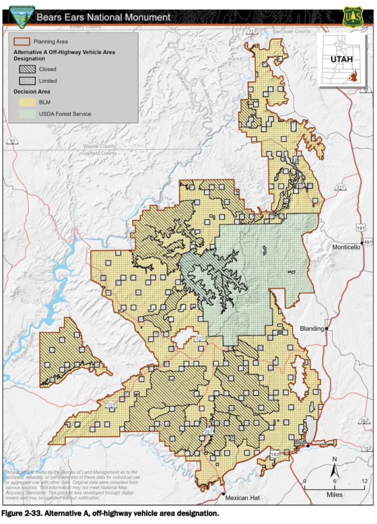
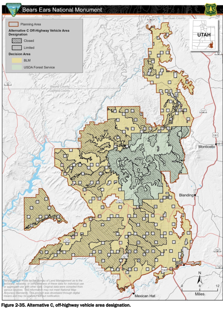
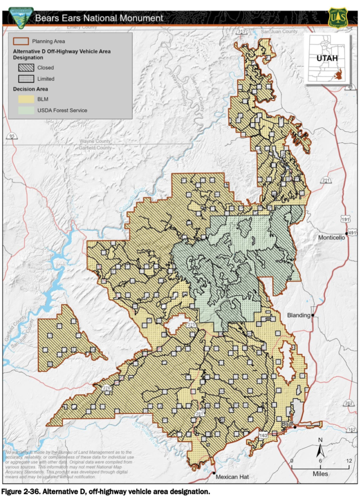
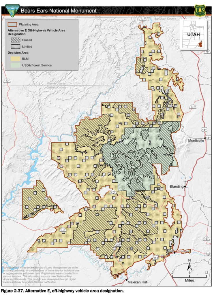
The Bureau of Land Management in conjunction with the U.S. Forest Service have released the proposed alternatives for the public to submit comments and feedback on for the next 90 days until June 11, 2024. Alternative A is the current management objectives, goals and restrictions. Alternative B-E give the proposals the agencies are considering moving forward with the management of this massive area.
Upcoming Meetings:
April 16- Virtual 3-4:30 Register to attend on Zoom
April 18- Salt Lake City 6-8 Marriott University Park, 480 S Wakara Way
April 23- Blanding, UT 6-8 USU Blanding
May 2-Virtual 6-7:30 Register to attend on Zoom
May 6- Twin Arrows, AZ 6-8, Twin Arrows Casino Resort, 22181 Resort Blvd
May 7- Albuquerque, 6-8, Abq Courtyard Marriott, 5151 Journal Center Blvd
May 16- Monument Valley, 6-8, UT Monument Valley High School
Full Briefing
Alternative D would designate 982,914 acres as closed to OHV use. Alternative E would close 569,971 acres to OHV use and designate 794,181 acres as OHV limited. In no alternatives is any acreage would allow open OHV use. The most popular OHV route within the monument that is proposed to be closed in both Alternative D and E is Arch Canyon Road.
Alternative E is the agency’s preferred alternative, with Alternative D being the most restrictive. Alternative E will maximize tribal consultation for management of Bears Ears NM which leaves much to be decided. This alternative is based on tribal, traditional beliefs from the Bears Ears Intertribal Coalition which is largely tied to Southern Utah Wilderness Alliance that advocates for the Red Rock Wilderness Act and OHV closures across Southern Utah.
Lands with Wilderness Characteristics: 419,128 acres will be managed as lands with wilderness characteristics under Alt. D. There is also a proposed aquifer ACEC in Alt.D that covers almost the entirety of the monument covering 1,012,371 acres, the only acreage not included is the Manti-La Sal National Forest. Areas of Critical Environmental Concern are not well defined, often restrict motorized use and are used as justification to implement restrictions and closures.
Alternative E (recommended) will have the following restrictive designations:
- USDA Forest Service recommended wilderness
- WSAs (381,920 acres)
- Lavender Mesa ACEC (649 acres)
- Indian Creek ACEC (3,936 acres)
Drone use is recommended to be restricted. Drones are not only used for photography purposes but recreation, and ranching purposes to find lost cattle.
Because wood gathering has historically been allowed throughout the monument, in order to create OHV closure areas, the BLM is proposing to restrict wood gathering. Much of the population of the tribal members and local community members use wood burning stoves to heat their homes. By restricting wood gathering, it is going to create unnecessary problems for locals to heat their homes throughout the cold winter months. This will not just create an economical issue but changes the local values and culture.
Target shooting is also going to be restricted throughout the entirety of BENM in the preferred alternative, again, altering the local traditions and culture. It is unreasonable to exclude target shooting across the whole monument, when some of the alternatives have less restrictive means for protecting public safety.
Hiking closures would be implemented in the preferred alternative per the tribal commission recommendation. The tribal coalition is recommending closing large areas to all users – including hikers – completely restricting who will be able to view these landscapes.
SITLA land. Approximately 130,000 acres of Utah Trust Land Association (SITLA) lands are within the BENM boundaries. When the monument was created, it locked up this land as inholdings. In 2023, Utah’s Governor Cox signed a memorandum of understanding with the U.S. Interior signaling they would trade the SITLA lands out of the monument for other Interior lands, leaving the 130,000 acres of SITLA lands within the monument to be owned and managed by the federal government. In 2024, a joint resolution was passed in the Utah legislature to reject the proposed land swap, keeping the SITLA parcels within Bears Ears National Monument. It is clear from the RMP proposals, the agencies were expecting the land swap as many closure areas are around SITLA lands. The time it takes to create a draft RMP suggests that modifications were not made once the swap was rejected by the state of Utah. These plans make it clear that the State of Utah needs to preserve its SITLA inholdings to maintain access, local traditions, and culture within the monument.
OHV Closure Map Comparisons of Different Alternatives