
The Manti-La Sal National Forest has submitted a Revised Forest Management Plan. The forest is more than 1.4 million acres and spans from San Juan County, to Utah County. If you recreate in Southern or Central Utah, chances are you have come in contact with the Manti-La Sal National Forest.
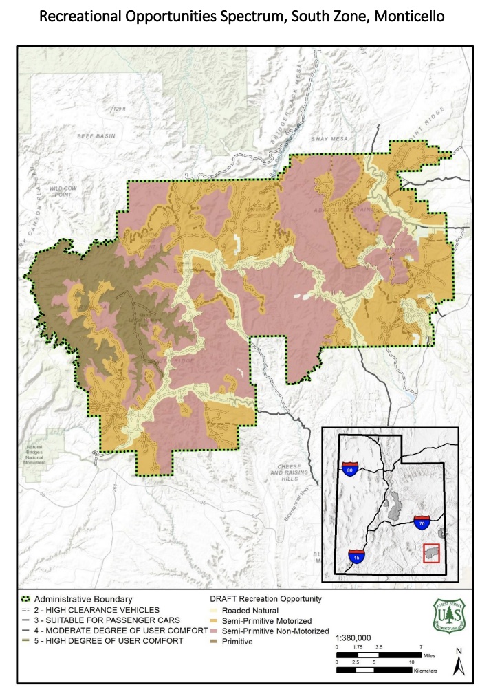
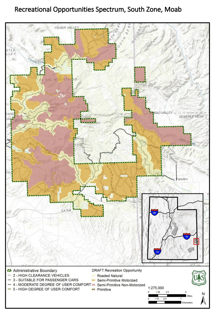
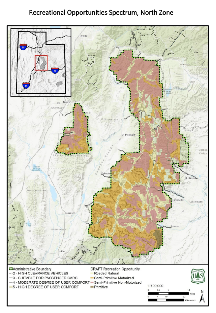
The plan highlights different types of designations with various degrees of restrictions. The green and pink areas that you see in the map will have all existing roads and trails closed. This is a very large area and we are concerned with the amount of access that will be taken away from users. From Arch Canyon, to the Arapeen Trail, to the towering peaks of the La Sals, to some of the best snowmobiling terrain in Utah, this plan will impact a wide range of recreation users.
As you can see, these areas shaded pink and green cover a large portion of the forest.
Here is the map of the Blue Mountains near Monticello and Blanding:
Here is the proposed map for the La Sal mountains that tower over Moab:
Here is a map of the National Forest lands near Manti:
We have been analyzing this plan, and we have prepared some initial comment language you can use to protect our access in this huge area of Utah. Fill out the form below to submit a comment to the Forest Service.
Add in your own additional, personal thoughts in the letter or use the comments we have provided.


We, the people of San Juan County do not approve of more road closures hindering our freedoms and our way of life.
I am not in favor of closing our public plans who we pay taxes on so we can recreate In our motorized recreational vehicles please keep all roads and trails open For motorize recreation. There are a lot of people who are physically unable to hike or walk in because of physical disabilities. Do not lock us out of our public lands.
I do not support closing down any more of our public land. It’s public!
1.3 million acers, how much of that is actual road? I would assume not a great percentage.
As a San Juan County Resident, I do not want more restrictions.
I am not in favor of more closures! We have already had a bunch of them and places we used to love and enjoy with friends and family are taken from us! And now more? Leave a unbroken system alone!!! You wouldn’t buy a new car battery install it and think hmm it’s not my color and go buy another one! Just leave the system alone!
Please do not close the trails and areas! We use them!
I travel through these Harry is often. I do not support the closure of these trails.
We need to maintain equal access for all users of public lands, no matter how they choose to recreate. In addition, people with disabilities that limit their abilities need motorized access. Don’t discriminate. Do not close any additional roads.
As a 72 year old Disabled Vietnam Vet, the only way I can see the beauties of Utah is using a motorized vehicle. Closing MORE of the back country really impacts my rights that I and others with disabilities in Utah have enjoyed. Please reconsider the infringement of my and others ability to enjoy the outdoors.
Quit closing our roads and trails, we want them open!
Manti is an amazing and beautiful place. I do not support any more restrictions of this area. This area like many other rural areas in Utah depend upon tourists and travelers to come see this amazing place.
I am strongly against any more closure of any Forrest road
I am not in favor of closing our public plans who we pay taxes on so we can recreate In our motorized recreational vehicles please keep all roads and trails open For motorize recreation. There are a lot of people who are physically unable to hike or walk in because of physical disabilities. Do not lock us out of our public lands.
Please allow your existing legislations to continue to maintain this Forest. More layers of beauracracy do nothing to benefit anything. We need access to our forests for all types of uses.
Don’t close the trails!
I am definitely not in favor of any more road closures. I believe that a lot of the road closures that have happened need reopened. A lot of people that can no longer hike enjoy those roads and trails. That is public land and needs to stay open to the public. Those roads can also be utilized by emergency personnel both fire and search and rescue.
Please keep our public lands open to all of the public.
The federal government needs to keep their hands off Public lands! They belong to everyone, including people who drive atv’s , and utv’s. Keep roads and access open to all!
The boot lickers in the Forest Service are only doing what they are told to do by the ball lickers in Washington DC. The ones in Washington are Democrats and puffing out their chests to show their authority but blowing out their chests that they are nothing but a bag of wind. Please contact your Congressman and tell them no, hell no. By a concerned citizen no longer able to walk or hike in the forest. I like to fish and hunt but I can only do it in a motorized vehicle.
I’ve lived in lasal for 42 years don’t close anymore trails or roads
My family has rode over 1000 miles in 6 months in this area. I have family members with health issues that getting out is difficult. These trails are perfect for family outings day rides etc. These trails provide families ways to recreate responsibly. Please leave us places to ride and enjoy this sport!
I’m apposed to the closing of any of these trails.
The Forest Service needs to stop proposing closure of roads and trails on public lands. The Forest Service exists to keep these lands USABLE and IN USE. I am opposed to closure of any of our public lands and request that the the ones that have been closed be re-opened. These are public lands for public use. Keep them that way, please.
The Manti-La Sal National Forest is PUBLIC land, and by law is managed for mixed use.
Mixed use requires that the land be accessible to the public. Any further restrictions on access, motorized or not, are contrary to the intent and spirit of the law.
Please keep the roads and trails open and maintained. I know resources are scarce, but there are groups who will help maintain access and encourage responsible behavior among those who use our lands.
What good are public lands if the public is not allowed to use them? We have enjoyed countless rides in these areas! We love to be able to see the beauty of our state. PLEASE keep these lands open!!!!!!
My wife and I travel at least 1,000 miles and hundreds of hours each Spring-Fall season. Our rides extend all over San Juan County and utilize all of our wonderful trails and roads that allow access to this beautiful area. We stay on all legal trails and roads and I request you keep them open so I can continue to enjoy my freedoms of exploring this great area, which I do pay taxes to do so.
Please do not close these roads and trails. We the people are the landowners, not the government. We want to maintain what we have, stop the restrictions now. We have able to enjoy this beautiful country for years by accessing these roads. Please reconsider.
How can they close trails and roads that have been there for years. From what I have learned if the road or trail has been open to the public for 10 or more years it can not be closed. But I guess if THEY have anything to do with the government THEY are above the law! It makes me angry and sad!!
Public land is for our use. We the people are tired of being locked out!
I am from Washington County. I travel to all these areas to explore and recreate. Do not close any roads in these areas or any area.
I served on a committee to keep our current roads and trails open. Why do we have to continue to spend tax dollars to re-hash the same things every time we have a democrat president? Most of our little towns depend on the tourist dollars spent on recreation. Please leave the roads and trails OPEN!!! There has been a lot of volunteer time on these trails. There are PLENTY of places to hike for the non- motorist young generation. Leave our trails and roads open!!
Keep locking up our land and soon we won’t even be able to go outside. Stop closing the land. This is our land. God gave us this beautiful place to enjoy not to let it sit and rot away.
NO MORE CLOSURES. NONE. ZERO. ZIP. NADA. Enough is enough.
We love this area, it would be a shame to close these areas off keep the roads and trails open.
The Forest Service needs to stop proposing closure of roads and trails on public lands. The Forest Service exists to keep these lands USABLE and IN USE. I am opposed to closure of any of our public lands and request that the the ones that have been closed be re-opened. These are public lands for public use. Keep them that way, please.
This is starting to get out of control, how much more land would you like to close for motorized vehicles? I don’t restrict others hobbies that I don’t partake in but please stop restricting my hobbies that I’m guessing you don’t like or partake in. Please keep all off-road areas and trails open.
The Semi-Primitive Non-Motorized area around Mt Peale in the La Sal Mountains needs to remain open for snowmobile use. In the summer, the area is inaccessible, but during the winter the north and south sides of Mt Peale are used regularly by snowmobilers and skiers alike. The locals in the area use snowmobiles around Mt Peale for recreation, to manage irrigation infrastructure, and for search and rescue efforts in the winter time. Closing it off to snowmobile use would be nearly impossible to regulate since there are so many access points around the base of the peak.
Please keep our access open to the trails we have grown up with and love. How can we enjoy the beauties of county if every bit of it is taken away.
I am opposed to any trail closures. More trail closures mean lower taxes? No didn’t think so. We pay for it! Leave it alone. ( go back to California)
Just another land grab by our government to limit the public use of the land. They do it all the time here in California and now its spreading. Soon there will only be wilderness lands even those that have been mined and logged are considered wilderness. How does that work?
I am not in favor of any road closure that restrict our free movements in our national forest or public lands
The Forest Service needs to stop proposing closure of roads and trails on public lands. The Forest Service exists to keep these lands USABLE and IN USE. I am opposed to closure of any of our public lands and request that the the ones that have been closed be re-opened. These are public lands for public use. Please keep them open.
We are opposed to any restrictions or Closures proposed to the Manti-LaSal National Forest or any National Forest. My Family and Friends use these lands EVERY YEAR and cherish the time we get to spend in OUR National Forest. The threat of closures and restrictions needs to STOP. The USNF needs to stand up to SUWA and counter sue for the Frivolous Lawsuits that waste our Forest Service money. This money needs to be spent on more Rangers and Summer Hires to maintain what we have and not close anymore PUBLIC LANDS!!
I do not believe we need any more road closures. Access to trails and mountain roads has continually declined over the years. I feel that there are areas that need additional trails built as connectors between current trails to provide safe trails, loops, and so that ATV users don’t have to make the connection by traveling down paved roads. As far as marking any of these winter areas as nonmotorized I believe is foolish. There is no disturbance to the land during the winter recreation. Snowmobiles in most cases are traveling on multiple feet of snow. The snow is too deep for most animals and so that is also a non issue. I hope we can get to a point that we are not locking out the locals from enjoying the landscapes they have enjoyed for generations so that someone in Washington DC who has never been here can feel like he is protecting something he knows little about.
The National forest, America’s playground. Was always a theme we have known the forest to be. It can only be closed if we allow short sighted people to do so. Conservation is the wise use of a resource whereas Preservation is the non use of our resources.
It is time that the West stop being treated like a colony park for the East. We live here and are tired of seeing our lands locked away. Let the western states decide what is best for themselves. Utah has a very good system of parks and trails. We can decide for ourselves what needs to be done or not done.
I am adamantly opposed to the closing of these public lands!
Should the trails and roads actually be closed not only would the local economy feel the pain, but sales of OHV’s, ATV’s and Jeep’s would drop across the United States.
The riders that use this area contribute millions of dollars across the United States every year.
We are also growing more astute in the political arena and getting actively involved.
I explore you to reconsider the proposed actions.
I believe that we have the right to access to our beautiful forest and public lands. We’ve been using the existing Trails for years and they are established and enjoyed but all types of people, including those with impaired mobility. Don’t you dare restrict access that we’ve been using for decades. Don’t cower to suwa and other restricting organizations. We deserve to be able to see and enjoy the country that we’ve been enjoying for so long.
I don’t see the purpose of closing the trails which give access to such beautiful country to many more people than would otherwise be able to see and enjoy the magnificence of these forests and lakes.
We shouldn’t have to be “asking them not to close land. ” Along with all the other Unconstitutional things they are doing every day. They feel above the law, do not respect the Constitution and steel more and more land regularly. They are tyrants.
Keep the trails open!
I am not in favor of closing our public plans who we pay taxes on so we can recreate In our motorized recreational vehicles please keep all roads and trails open For motorize recreation. There are a lot of people who are physically unable to hike or walk in because of physical disabilities. Do not lock us out of our public lands.
In previous travel plans, the roads were deemed acceptable for motorized use. Now, for some reason, they are not. Political pressure should not be how are public lands are managed.
Please dont close anymore of our access to public lands.There are many older, younger and disabled generations that like to go out and enjoy the trails and area that, they normally wouldnt be able to without being able to be in a motorized recreational vehicle.
I have been a lifelong resident of San Juan and Grand Counties. My childhood and adult life is based on the ability to be able to spend time in the Mountains.
This further restriction will be detrimental to our communities! We are law abiding citizens that enjoy having the ability to recreate each Season of the year. We are law abiding citizens being punished for loving the country that surrounds us for no specific reason.
Like I said before this will be a very punishing blow to the Citizens of Southeastern Utah in a catastrophic way. Think about that.
I am against any type of closures on the Manti lasal’s that means road closure’s or closing dispersed camping all government wants to do is close everything down instead of managing it… If anything we need more access to get in and keep the forest clean!!! Closing Roads just causes more of a problem for access. Here is another thought open more Roads and don’t charge for fire wood that is already ours you know we the people that actually own that land not the federal government… Government has gone to far and its time we the people take our land back from you Bureaucrats!!!
STOP WITH THE CLOSURES. Roads have been closed already, that were used by our grandparents and there parents. Roads that were 3-4 times as old as the people closing them. There are people that enjoy the mountains, and spending time with friends and family that would be unable to do so if these closures happen. We pay taxes for these lands, everyone should be able to use them. Therefore it wouldn’t be acceptable to close roads and trails down, for motorized access and limit people that can use them.
I am totally against closing down any more of the LaSal Mountains for any reason. Over the year the Forest has changed the character of the whole Federal Forest and it still continues. Access roads used by hunters have been converted to bike trails right through some of the most productive hunting areas. Access roads utilize sports persons to cross over some of the passes have been disregarded and in such bad order that the only ones using the roads are UTV’s and other All-Terrain vehicles. Now you are widening roads to get be able to get more tour companies hauling bicker to the top of the mountain quicker. You’re destroying the LaSal Mountain range.
I am not in favor of the closures. Just one more giant step to try and take away more of our freedoms. We have enjoyed these areas for years and years, these lands belong to us, the people. POWER to the people, we’re getting really tired of being pushed around! If a tree falls in the forest does it make a sound? You don’t know because you turn a deaf ear to the wants of the people.
I support multiple use of all public lands so long as it can be done responsibly and with minimal impact. Education and enforcement of rules and etiquette should be applied with increased funding and proper application instead of closure of motorized travel and denied dispersed camping. Conservation is the wise use of a resource whereas Preservation is the non use of our resources. Do not discriminate against cultures and classes of people.
This is ridiculous. Why don’t you figure out how to grow some local produce on this land instead of always trying to shut it down? Be useful with our tax dollars FOR ONCE!
My family and I visit areas of these closures three to four times per year and
do our part in protecting the trails and surrounding areas from damage and trash for ourselves and others to continue to enjoy. (TREAD LIGHTLY). Please tell me why these closures are necessary?
We spend thousands of dollars on our vacations to these areas which supplements State & County businesses and aside from that we pay a generous amount of FEDERAL income tax, to keep our public lands open to ALL of the people .
PH
We do not support the restrictions and closures proposed in Manti-La Sal National Forest. These mountains have been a great source of joy for us for recreation, including mountain biking. Hear the voice of the people who live near and use these lands.
Do not restrict Dispersed Camping, shut down our trails. In all recreation forms this is the last way for all recreational uses to get out side and explore.
Please keep these roads and trails open! Our family spends days and weeks every year in this area riding off road vehicles!
I am in opposition to anymore road closures and restrictions on dispersed camping on the Manti Lasal National Forest. I have spent my entire life camping and recreating on all 3 systems of the MLNF. I agree that there has been a remarkable increase in the number of people recreating in recent decades but closing and restricting is NOT the answer to enforcement of the laws and regulations that are compromised. Stricter policy and closures only limit and shut off activities that people such as myself have been responsibly enjoying for hundreds of years. Recent decades have seen government agencies cave to “politically correct” environmental groups agendas taking away the true multiple use of our public lands. It is time to provide better enforcement of the policies we now have with out forcing further limitations on these areas. Recent decades and political pressure have seen the true multiple use part of of public lands take a beating. It is time to stop the nonsense.
Please keep our public lands open and accessible to all.
Stop closing roads! I don’t know who writes these reports that lists the majority of the roads as “Likely Unneeded”, but they obviously aren’t part of the crowd that travels the area, recreates, lives in the area etc.
For everyone commenting above, please note you need to go to this link and actually submit the e-mail message to the Forest Service:
https://www.sharetrails.org/restrictions-and-closures-proposed-in-manti-la-sal-national-forest/#/2/
I oppose the continuing trend of closing of more and more public land. As our nation continues to grow, we need access to these beautiful places to feed our spirit and feel free. Besides, closures run contrary to the creation of “public” land in the first place!
Our family does not approve of more and more closing of federal lands . We love our open spaces and greatly enjoy our ability to enjoy them first hand . The concept of multiple use of those lands provides us those opportunities. Certain special interests should not be allowed to keep other tax payers from enjoying those lands. Because of age and or health concerns many of us can no longer back pack or hike as we did when we were younger. It becomes important for us to maintain our physical and mental health by getting out in nature and driving those roads that have been available for the general public over a hundred years.
Our family does not approve of more and more of our public lands, and access to those public lands via established roadways, which have been available to everyone for over 100 years , be taken away from them by special interest groups. We are also tax payers and those lands also belong to us. As we age ,we are no longer able to hike and backpack as we did when we were younger. In order for us to enjoy those PUBLIC lands we need to be able to travel on those long established roadways. It becomes important for us to maintain our physical , mental and social health to be able to travel into and enjoy nature. Multiple use is the answer to making our lands available to us. These lands and roadways should be open to all.
I grew up recreating in these mountains. Anything from fishing, camping, four wheeling, hiking, biking, etc. I think it is wrong to close these beautiful lands off to some recreation. Sometimes OHP is the only way that some of the people can enjoy this beautiful area. Closing off this area would be heartbreaking. So much of my life has been spent in these mountains, to have that taken away would be so sad. I hope to get to share this beautiful place with my children and grandchildren. Law abiding Citizen should not be punished for those who break the law. Harsher punishment for those who do break the law is a better option.
I do not support closing our public lands!
Please do not restrict our access to public lands in San Juan and Grand Counties. We have been using these lands responsibly for generations. Our home borders Manti La Sal National Forest. That is where we chose to live as we love our forest. Our family enjoys snowmobiling, hiking, and camping all year long. Don’t take this freedom from us as so many of our other freedoms are being taken.
I am NOT in favor of any road closures. Everyone should have access to all roads. If roads are closed to ATV’s then you are taking away peoples rights. For some of those people ATV’s are the only way that they have access to view the beauty that is around us. Do not close any more roads!!
I find it absolutely hypocritical that i constantly hear radio ads urging children to get their parents to take them to visit the forest when they don’t even want us to enjoy it! I am 5th generation Moabite, our grand children are 7th. We love our family time on the LaSals and we do not want any more closures. They have already closed off roads and trails we have enjoyed all of our lives. The Forest Service and taken enough of our rights away and we say NO MORE!! They need to do their job and write tickets to the few who do the damage, instead of punishing the many who love and respect our Mountain.
As a Moab native, i spent a lot of time in the La Sals with my dad and grandpa who used to own a gold mine there. Closing roads and restricting access to more public lands only hurts the community. Moab was built on mining and it’s unfortunate the current officials are trying to take away recreation areas from people who stimulate and support the local economy.
Being recently retired and have in the past ridden this area 3-4 times a year. We do not want to have more trails closed for the recreation of those who love this area and take care of it while riding. Please consider those of us that are now in the “Golden Years” and will enjoy the outdoors more often while taking care of those areas. Always bring back what you take and for those that can’t pick it for them and respect the outdoors!
In a time when social distancing is preferred why in the heck would you want to close more roads? Utah offers some of the most beautiful scenery in the world! Do not close more roads if anything open more up! Open up this beautiful country to those who recreate responsibly. Don’t let the 1% ruin it for the rest of us! I do not support anyway shape or form the closure of additional roads.
I do not support more closures within our public lands. My family enjoys recreating in the La Sal Mountains year round and have already seen far to many trails closed.
I vehemently oppose road closures. Proposed closures of existing roads is just another example of why so many Americans find fault with our government. Rather, we should be focused on what is being done to ENHANCE and EXPAND access to these lands? Let your work lean toward improving the public experience and away from destroying that experience – please.
It is never a good Idea to close roads. You need to consider the fact the some of us have long used these roads and what should happen if there is an emergency. We have had truck troubles and have had to walk many miles because of roads that were closed. We love to just ride through the mountains and as we age you are discriminating against because we could not walk those long miles again. Age discriminating is becoming a big problem. We have little left we can do but we can or could go for rides. Do not close roads and deprive us of what little pleasure we have in life.
I have lived in southern Utah my whole life and feel you are trying to take away everything. Closing roads is dumb. How are we supposed to get around. Leave the roads opened.
I as well have a San Juan county address and operate businesses in the county , lived here for over 30 years , Please do not shut down more trails and roads , the need is there and the citizens love to recreate , at 56 my body can no longer hike or skin -up to these places motorized access is a must please no more closures !!
Please keep motorized access and dispersed camping in all areas of the forest
As an active UTV rider I absolutely do not agree with these proposed changes. There are many ways to address the issues that are bringing this forward. Closing the areas is not one of them. This needs to go back to the drawing board and the next time be much more inclusive with all of the users of the lands or as an alternative turn them back over to the state and let the state control access.
Leave our trails alone. These trails have existed for hundreds of years and we enjoy them.
Please do not close anymore roads or trails. We have a right to these lands and there is nothing being hurt by our use.
I am 67 years old. All my life I have enjoyed the wilds of Utah. If you close these roads I will no longer be able to go out because physically I need a vehicle.
It’s like discriminating against anyone with physical limitations. I want to be able to show my grandkids the beauty of this state.
Utah is so different from one area to the other. If you close so many roads alot of these different terrains will not be seen. Like I’ve told my children. Go 4 hours any direction and you can see any landscape to be seen.
The growth in Utah is growing crazely. We need places for everyone to go. If you close this many roads the ones left will become overrun causing more problems. Please don’t take the joy of seeing such a beautiful state away from us.
Any update in this?
It usually take months or years between the different steps of these plans.